 |
|
Fairfax County Chesapeake Bay Changes on the Way
|
Resource Protection Areas Expand by 11,000 Acres
The Fairfax County Planning Commission has approved amendments to the Chesapeake Bay Preservation Ordinance (and related sections in the Public Facilities Manual, Subdivision Ordinance and the E&S Ordinance). These changes will go to a public hearing with the Board of Supervisors on May 19, 2003 at 4:30 p.m. The recommended effective date is July 18, 2003 – five months before new Resource Protection Area (RPA) maps are expected to be completed.
These amendments change the definition of the RPA (i.e., areas near streams where only water-dependent uses are allowed unless exceptions are granted through a public hearing process). County staff estimates that approximately 17.7 square miles (11,300 acres) of land not currently designated as an RPA will become an RPA. Expansion of existing facilities or homes in these areas are limited to the greater of 1,000 s.f. or 2 percent of the lot area. Accessory structures, such as sheds or pools, are no longer permitted in the RPA
without an exception granted in a public hearing. A complete copy of these
changes will be posted soon on
Fairfax County's website.
The specific streams that will form the core of the RPA will be based upon a field study to determine whether or not they have perennial flow. County staff have completed mapping 40 percent of the County and expects to finish field work for the remainder of the County this October.
Interim maps show the RPA based upon these field studies and estimates for the rest of the county.
The “Interim Map” provides you with general policy guidance as to the “ballpark” extent of the RPA. However it is not of sufficient accuracy for individual homeowners to rely upon – as suggested by some. This map uses the median drainage areas of perennial streams in the pilot studies (40 acres in Piedmont, 50 acres in Coastal Plain). However, for example, the range of drainage areas for perennial streams in the Piedmont study was 11 acres to 282 acres. The data for the drainage area of where a stream’s flow becomes perennial for 278 streams, provided by Fairfax County1 shows this scatter:
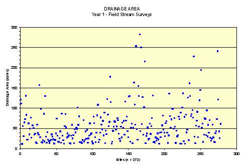
Clearly, since it’s not proposed to make the interim map definitive – the effective date should be deferred until the map is completed if citizens are to be provided a reliable way to determine if they are faced with RPA issues. The Planning Commission's recommendation will require field studies by the land owner to define the RPA streams in the interim period between July 18, 2003 and December 31, 2003, when the map is expected to be completed by Fairfax County staff.2
Several issues have been noted by many homeowners, civil engineers, environmental scientists, financiers, and land developers that will increase the uncertainty and costs of this proposed regulation. The biggest issues are:
1.
Effective Date. The state does not require these changes to
occur until December 31, 2003. By proposing to effect these changes on July 18, 2003 – 5 months prior to
completion of the RPA maps - landowners in much of the County cannot be certain
if they are affected without conducting a field study. Even if your property is currently outside of
the estimated RPA, your property could potentially be included in the field
verified RPA zone.
2.
Stream Width. The County proposes to define the width of a
stream differently than what the U.S. Army Corps of Engineers (COE) and
Virginia Department of Environmental Quality (DEQ) define as the width of a
stream. The difference is depicted
below:
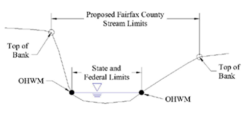
This will increase the extent of
the RPA and the cost of locating these boundaries as often two parallel lines
will need to be flagged and surveyed. It is
not required by the state.
3.
Vesting. The County does propose to provide vesting for
projects in various stages of the approval process (see
Fairfax County's
vesting policy memorandum). However, unlike Prince William
County, Fairfax is not proposing to vest Resource
Protection Area Plans approved by the County. People that have expended time and money to
prepare an RPA plan and have financial expectations in reliance
upon this boundary, will not be able to rely upon this previous
County approval. Prince
William County
determined that state law required RPA plans to be vested
for 5 years after their approval.
Fairfax
County has reached
a different conclusion.
What Should Property
Owners and Taxpayers Do?
- Examine the
Interim RPA maps at
Fairfax
County's website and see if it's likely
that you are affected.
- Review the
proposed changes. (New changes dated May 6 and May 7
should be posted soon.)
- Participate
in the BOS public hearing on May
19, 2003 at 4:30 p.m.
in the Board Room of the Fairfax
County Government
Center,
12000
Government Center Parkway, Fairfax,
VA. You can sign up to speak in advance
(call: 703.324.3151) or show up and speak after registered speakers have
finished.
For more information on this topic contact Mike Rolband at
mrolband@wetlandstudies.com or Mark
Headly at mheadly@wetlandstudies.com.
|
|
 |
|